AccuWeather sees a high chance of a powerful storm forming in the warm waters from Mexico’s Yucatan Peninsula to Florida.
AccuWeather sees a high chance of a powerful storm forming in the warm waters from Mexico’s Yucatan Peninsula to Florida.

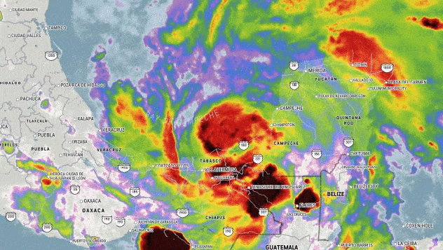
The first organized tropical system of the 2022 Atlantic hurricane season could form as soon as Thursday, AccuWeather forecasters said. On the eve of the official June 1 start date to the tropical season in the basin, meteorologists said there was now a “high” chance of a depression or tropical storm forming in the warm waters from Mexico’s Yucatan Peninsula to around the Florida Peninsula.
Meteorologists say there is already some risk that the burgeoning tropical rainstorm, which would be called Alex once it hits the 39-mph maximum sustained winds threshold for a tropical storm, could cross Florida at the end of this week and then the northern Bahamas this weekend.
Areas where the rainstorm could first develop a circulation, become a tropical depression and evolve into a tropical storm, include the northwestern corner of the Caribbean Sea and the southeastern portion of the Gulf of Mexico. It is also possible development of a tropical depression or named tropical storm is delayed until this system is located just east of Florida.


The dissipation of Agatha, which struck southern Mexico Monday as a record-setting hurricane, is likely to play a role in the formation of a tropical rainstorm on the Atlantic side of Central America. Another key factor is a broad area of weak low pressure and clusters of thunderstorms around Central America and southeastern Mexico, known as the Central American Gyre, and a decreasing amount of wind shear over the Caribbean.
“A highly likely solution is for moisture and residual energy from Agatha to give birth to a new storm system on the Atlantic side,” AccuWeather Senior Meteorologist Courtney Travis said.
Waters are sufficiently warm for tropical development, and the temperatures are generally a few degrees above average and in the 80s F. Water temperatures surrounding western Cuba and the Florida Keys are in the mid-80s. If a budding tropical rainstorm was to wander into the very warm water, the storm could strengthen rapidly, experts say.

“There is strong wind shear in the region at the start of this week, but it appears that these disruptive winds will drop off as the week progress,” AccuWeather Lead Long-Range Meteorologist Paul Pastelok said. Strong wind shear, the sudden change in direction and the increase in speed of winds throughout the various levels of the atmosphere, is one of the key obstacles to tropical cyclone development around the world.
“How quickly wind shear dissipates may be a major determining factor as waters are very warm over much of the proposed path of the tropical rainstorm, plus there is extra energy circulating around the topical part of the globe that could really give this system a boost as it nears Florida,” Pastelok said. A small or medium amount of wind shear can actually assist in tropical development and strengthening of a tropical system in some cases.
Regardless of whether the system becomes a tropical depression or tropical storm, it will approach Florida with drenching downpours and gusty thunderstorms from Friday to Saturday and then impact the northern part of the Bahamas from Saturday to Saturday night.
“In addition to showers and thunderstorms, there is the likelihood of urban flooding, building seas and surf,” AccuWeather Senior Meteorologist Brett Anderson said, adding that there is also the potential for a few tornadoes and waterspouts as the system, at the very least as a tropical rainstorm, crosses the Florida Peninsula or passes just to the south of Florida.
Parts of South Florida could use a good soaking due to ongoing drought or abnormally dry conditions this spring. While the center of the storm may not reach the Florida Peninsula until Saturday morning, heavy rain could precede the center by 24 hours or so.
How quickly the system organizes, how strong it becomes and its exact track will determine the severity of the impacts on Florida, Cuba and the Bahamas into this weekend. Experts say recreational boaters and officials in the offshore fishing and shipping industries should keep a close eye on the development and track of this tropical system.

After it passes Florida and the Bahamas, the system is likely to spin northeastward along the southern Atlantic coast of the United States for a time next week. The storm system’s proximity to the coast and strength once on the Atlantic side of the southeastern U.S. will be key in determining the level of impacts experienced from Georgia to the Carolinas and southeastern Virginia. Forecasters say potential impacts include building seas and rough surf, beach erosion, coastal flooding, and even gusty winds and rain.
Once the storm forms and begins its journey, AccuWeather forecasters will have more information on the severity of impacts moving forward.
Crossover tropical systems, such as the potential with Agatha, are rare. However, there is a fairly recent example of a former tropical system from the eastern Pacific that helped give birth to a new storm on the Atlantic side of Central America.
During the historic 2020 Atlantic hurricane season, Tropical Storm Amanda moved inland from the eastern Pacific over Mexico and began to unravel. But Amanda’s leftover energy, moisture and old circulation helped to give birth to Tropical Storm Cristobal in early June over the Gulf of Mexico, which went on to make landfall along the central Gulf Coast of the U.S.
There is another area of the Atlantic basin where a potential tropical system could take shape.

AccuWeather meteorologists were monitoring a general zone of showers and thunderstorms associated with weak low pressure currently northeast of the Bahamas Tuesday. There is a remote chance this area of disturbed weather could slowly organize as it drifts northeastward and out into the central Atlantic during the balance of this week.
Even though tropical development in the Atlantic will not occur prior to the official start of hurricane season this year for the first time since 2014, an above-average number of named systems and hurricanes are forecast by AccuWeather for the 2022 season.
Produced in association with AccuWeather.

