Long-lasting Tropical Storm Freddy’s deadly journey is nearly finished after the storm made its third and final landfall.
Long-lasting Tropical Storm Freddy’s deadly journey is nearly finished after the storm made its third and final landfall.

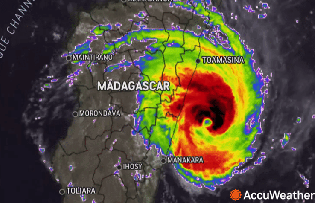
The deadly and destructive journey for long-lasting Tropical Cyclone Freddy is nearly over after the storm made its third and final landfall more than one month after its initial formation, AccuWeather forecasters say.
After being named on Feb. 6, Freddy took a westward track across the Indian Ocean, spinning from just northwest of Australia all the way to eastern Africa. Freddy has been affecting Madagascar and southeastern Africa for nearly two weeks, making three total landfalls and killing more than 90 people in Madagascar, Mozambique and Malawi.
The death toll surged in Malawi on Monday, as at least 66 deaths were blamed on the storm, with officials saying there were more than 90 injured and 16 people still missing.

The powerful winds and torrential rain from Freddy have significantly cut communications and electricity supply to Mozambique following its landfall this past weekend. Freddy is now a tropical rainstorm, or an overland depression, according to Meteo France. As such, officials fear that the extent of damage and the number of fatalities may rise.
More than a month’s worth of rain has fallen in Mozambique during the past four weeks, according to the BBC. An estimated 1.5 million people have been affected since the storm first hit last month, according to Mozambique’s National Disaster Management Agency, and more than 8,000 people are likely to be left homeless.
Freddy has lingered in the Indian Ocean basin as a named tropical cyclone for a total of 35 days and is likely now the longest-lasting named tropical system in history. The previous record was held by Typhoon John in 1994, which survived for 31 days. The World Meteorological Organization is expected to confirm this record in the near future.
Freddy has already gone down in history as a once-in-a-lifetime storm, having broken at least one record.
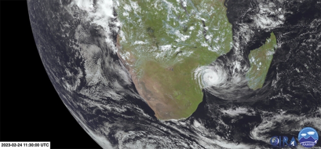
Freddy took an unusual path across the Indian Ocean and along the eastern African coast during its more than a month-long journey, which included a 15-day trek westward across the open waters of the ocean, before finally making landfall in Madagascar. Freddy then went on to meander through the Mozambique Channel for another two weeks, before two landfalls in Mozambique.

During that time, Freddy’s strength fluctuated, reaching the equivalent of a Category 5 hurricane in the Atlantic or East Pacific Ocean Basins more than once. Freddy was only the 20th tropical cyclone to reach this strength in the South Indian Ocean since 1989. In fact, Freddy re-intensified a total of seven times and traveled more than 5,500 miles.
As a long-duration storm, Freddy’s accumulated cyclone energy, referred to as ACE, was exceptionally high. ACE is a measure of a storm’s intensity over its lifetime.
According to Colorado State University, the ACE for Freddy is 84.7 as of March 13, which is more than the average total ACE of an entire Atlantic hurricane season. This ACE value is not only the highest ever recorded in the Southern Hemisphere, but it’s also close to the total ACE of Hurricane Ioke from 1980, the current world record-holder for a single cyclone at around 85.
After more than a month prowling the Indian Ocean and wreaking havoc over land, forecasters say Freddy could still pose additional concerns.
AccuWeather Meteorologist Alyssa Smithmyer says that Freddy is likely to drift southeastward over the next few days, continuing to become disorganized as it moves back into the Mozambique Channel.
Freddy has gone through this area frequently in recent weeks, promoting the upwelling of the waters in the channel. Upwelling is the process of very cold water, deep below the ocean surface being mixed in with the warmer water at the surface. Powerful tropical systems naturally will do this when they move through a body of water.
“The recent upwelling in the region has brought ocean surface temperatures down low enough that it would be unlikely for Freddy to regain wind intensity,” Smithmyer explained, adding that an increase in wind shear over the region will also likely be an inhibiting factor.
However, the lingering moisture from Freddy could push into southern parts of Madagascar for the middle of the week, adding even more rain to the already drenched area.
Produced in association with AccuWeather

