At least two people died in the bomb cyclone that struck the West Coast Wednesday into Thursday.
At least two people died in the bomb cyclone that struck the West Coast Wednesday into Thursday.

At least two people died in the bomb cyclone that struck the West Coast Wednesday into Thursday — the second massive storm to hit the coast in less than a week.
Fueled by an atmospheric river from the Pacific Ocean, the potent storm unleashed a fury of strong wind and rain across the West Coast that quickly turned deadly. A 19-year-old woman from Fairfield, California, was killed Wednesday morning when her car hydroplaned on a partially flooded road and crashed into a utility pole, according to the Fairfield Police Department. Fairfield is located in Solano County, nearly 40 miles northeast of San Francisco.
The second fatality was reported Wednesday evening, also in the San Francisco region, in Occidental, Sonoma County, after a tree fell on a home and killed a 2-year-old boy, local firefighters told ABC News.

“California just hasn’t been used to this for probably the last 20 to 30 years,” said Capt. Keith Wade, of the Sacramento Fire Department according to Fox Weather.
As of Thursday afternoon, more than 133,000 customers in California were without power. Most of them have been reported in Northern and Central California.
“This weather system by itself would present widespread challenges, and we have to factor in that many parts of our service area remain saturated after last weekend’s storm,” said Angie Gibson, vice president of PG&E’s emergency preparedness division. “We encourage customers to prepare for the storm now – have an emergency plan in case you lose power.”
Seaside homes were evacuated in the Bay Area county of Santa Cruz under the threat of landslides as the storm ushered in a combination of towering waves, drenching downpours and fierce winds. Photos showed ocean waves surging past the shorelines, the water flooding into nearby roads and moving dangerously close to beachside homes.
In Santa Cruz County, the rough surf heavily damaged piers in Capitola and Seacliff, including one that was split in half as one section collapsed into the ocean. One video showed a pier in Aptos, also located in Santa Cruz County, as a wave crashed into it, crumpling the structure into the sea.
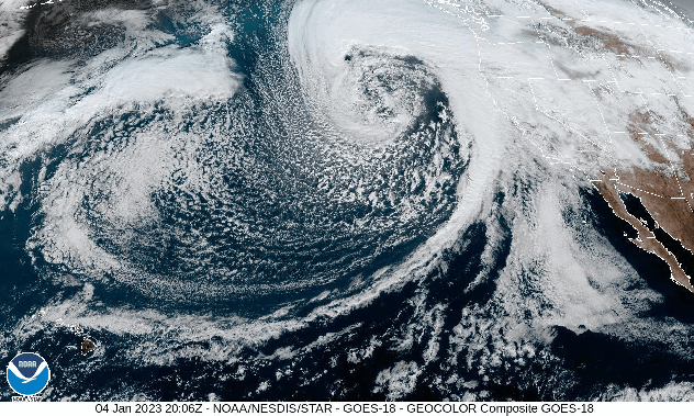
As the storm approached the coast Wednesday, the pressure in the center of the storm rapidly dropped, allowing the storm to undergo a process called “bombogenesis.” In this process, the barometric pressure must fall to at least 0.71 of an inch in mercury (24 millibars) within 24 hours, after which meteorologists may informally refer to it as a “bomb cyclone.”
The pressure dropped by 0.86 of an inch in mercury (29 mb) between 4 a.m. PST Tuesday and 4 a.m. PST Wednesday, according to an Ocean Prediction Center surface analysis, officially qualifying the storm as a bomb cyclone.
This process strengthens the winds associated with the storm, and it was certainly reflected in the recorded wind gusts. According to reports from Wednesday and Thursday, a 132-mph gust was recorded at Alpine Meadows, California, in Placer County, northeast of Sacramento. Farther east, a gust of 119 mph was recorded in Kirkwood, California, as well as in Palisades Tahoe, California. Of the recorded wind gusts from the storm, the strongest were recorded in Northern and Interior California.
CAL FIRE officials in San Mateo County, located south of San Francisco, tweeted that “firefighters were responding to non-stop calls early into the morning hours” on Thursday as the morning light revealed the extent of the storm damage. Trees had come crashing down amid the strong winds, bringing down power lines and sections of roofs along with them.
Over 26,000 power outages were reported in San Mateo County by Thursday morning, accounting for 16% of all power outages across California, according to PowerOutage.US. While that number had fallen slightly as of Thursday afternoon as crews ventured out to restore power, over 138,000 customers across California — primarily along the coastal counties of Northern California — remained without electricity.
The atmospheric river that fueled the system was unlike the one that soaked California on New Year’s Eve and killed at least three. This week’s storm was classified as a “pineapple express” as the moisture originated from the tropical Pacific Ocean near Hawaii, which is the nation’s leading producer of pineapples.
The concentrated band of moisture produced heavy rainfall across the U.S. West Coast, with rainfall totals ranging from less than an inch to over 4 inches in some locations in Northern California. In Shasta County, a site at Sims recorded 4.64 inches of rainfall, and Shasta recorded 4.03 inches.
By Wednesday, Downtown San Francisco measured its wettest stretch of 10 days since 1871, according to the National Weather Service. The site received 10.33 inches from Dec. 26, through Jan. 4. The all-time 10-day record was 14.37 inches in January 1862.
The San Francisco Bay Area, which saw its second-wettest day on New Year’s Eve, could see an additional 2 to 5 inches of rain with locally higher amounts according to the New York Post.
Even the Los Angeles area could have 2 to 4 inches of rain – with 4 to 8 inches of rain possible in the Southern California mountains – by the time the storm system moves through.
“We are seeing street flooding occurring on multiple streets throughout the City of Los Angeles,” Los Angeles Police tweeted Thursday morning, adding the Sepulveda Basin had been shut down due to high water levels.
Produced in association with AccuWeather.

